


Meet Alternatives 4 & 5

Sepulveda Transit Corridor Partners (STCP) is a consortium of U.S.-based companies with global experience, proposing two heavy-rail transit designs for Metro’s consideration: Alternatives 4 and 5.
Key Benefits
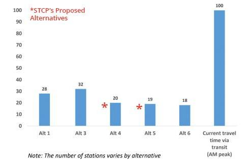
- Travel Times and Speed: With trains reaching up to 70 mph and arriving as frequently as every 90 seconds to 2.5 minutes at peak operations, travel times will be the fastest in LA history:
- Valley to Westside – 20 minutes
- Van Nuys to Expo Line – 20 minutes
- Westwood Blvd. to Ventura Blvd. – 6.5 minutes
- Wilshire/Westwood to Santa Monica Blvd – under 1.5 minutes
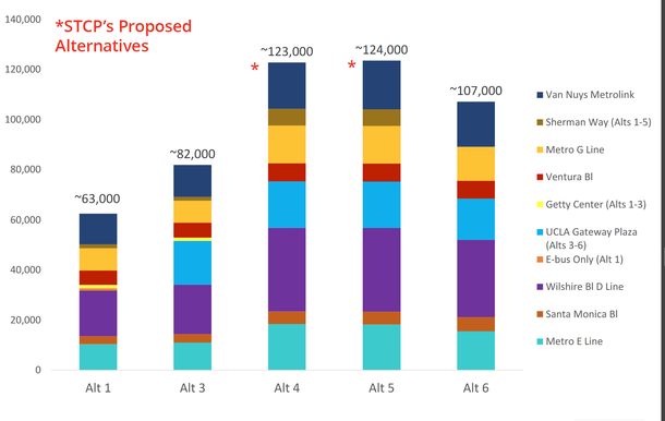
- 8 Convenient Stations: Alternatives 4 and 5 include eight stations strategically placed for easy access, allowing riders to park and board the train in just a few minutes. They are designed to accommodate high ridership numbers in each area.
- Reduce Nearby Congestion: Stations along the route offer quick connections to the D, E, and G Lines—giving commuters faster and more flexible ways to get where they need to go, which will help alleviate nearby traffic congestion.
- Designed to Minimize Disruption: Alternatives 4 and 5’s tunnel design and construction approach are intended to protect against aboveground disruption. The stations feature a compact footprint to reduce construction impact and limit environmental impact.
- More Connectivity and Travel Options: Seamless connections to Metro’s D, E, and G Lines, plus Amtrak and Metrolink, will offer passengers easy transfers to existing public transportation.
- Built for the Future: Alternatives 4 & 5 will deploy state-of-the-art technology, including driverless trains that will enhance safety, efficiency, and operational flexibility.
- STCP brings decades of collective experience building and operating some of the most innovative rail systems around the globe — from the U.S., London, Paris to Western Sydney and Riyadh.
Our 8 Stations
Strategically located in high-demand areas to maximize ridership and convenience.
